Understanding Old Boundaries: Why They Matter in Local History Research
- Fay McDougall
- Aug 26, 2025
- 3 min read
We have recently added some new Ordnance Survey maps to our collection here at Local Studies of Fixby. Fixby is currently in Kirklees, but this has not always been the case.
When you're digging into local history or tracing your family tree, boundaries both church and council are more than just lines on a map. They tell stories about who was in charge, how communities worked, and how things changed over time. If you're looking into land use, family history, or local government, knowing how and when these boundaries shifted can make a big difference.
In England, parish boundaries were especially important. For centuries, a parish wasn’t just a religious unit it also oversaw practical matters like road repairs and helping the poor. Highways Act of 1555 made parishes responsible for maintaining roads. Because of responsibilities like these, marking out parish boundaries clearly (with things like boundary stones) became essential.
As the population grew and society became more complex, the old system of church parishes gave way to new layers of local government like civil parishes and later, urban and rural councils. These changes didn’t just create more paperwork; they affected how records were kept, how people paid taxes, and even how local identities formed. If you’re doing historical research and you don’t take these changes into account, it’s easy to miss something important or end up looking in the wrong place.
Take Calderdale, for example. Today it’s a metropolitan borough, but its history is full of overlapping boundaries and shifting jurisdictions. For a long time, it was dominated by the huge parish of Halifax one of the biggest in England. Halifax parish included places like Heptonstall, Elland, Sowerby, and Fixby. Over time, especially in the 18th and 19th centuries, many of these places grew into separate parishes or became part of new local councils.

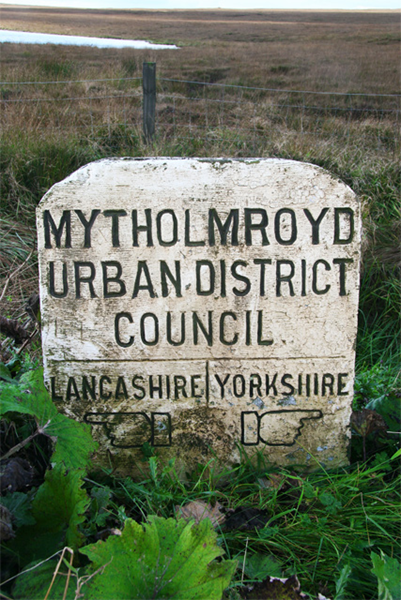
When the Calder Valley began to industrialise in the 1800s, the way the area was managed had to change. New boroughs and districts were created, sometimes splitting old parishes and causing confusion in the records. Places like Todmorden and Sowerby Bridge, which used to be chapelries within Halifax parish, became their own administrative areas. You can see these changes in old maps, and boundary stones from that era still show where those lines were drawn.

For anyone researching the history of Calderdale, it’s a goldmine but also a bit of a puzzle. A document filed under “Halifax” in the 1700s might show up under a completely different name by the late 1800s. That’s why understanding how boundaries changed is key. At Local Studies, we’ve got lots of parish records and local documents, but their value depends on knowing where and when they apply.

Fixby is a good example of how complicated this can get. It started out as a township in Halifax parish and appears in records as early as the 1200s. In 1866, Fixby became its own civil parish. But that didn’t last long by 1937, it had been absorbed into the urban areas of Huddersfield, Elland, and Brighouse.
So, if you're researching a family who lived in Fixby in 1850, you’d look in Halifax records. But by 1900, the same family might be recorded in Huddersfield or Elland. That means you might need to search several archives to piece together a full picture and know exactly when and how things changed.

Understanding old boundaries isn’t just something for academics it’s essential for anyone doing serious historical research. These lines decided where people paid taxes, where they went to church, and where their records ended up. As Calderdale and Fixby show, population growth, new laws, and industrial change all played a part in redrawing those lines.
Maps are especially helpful here; enclosure maps and early Ordnance Survey maps can show you exactly how things looked. And don’t forget boundary stones and old milestones; even if the councils are long gone, those markers can still be found out in the landscape.

For family historians in particular, knowing the right parish or district is vital. Baptisms, marriages, and burials were recorded by parish, and civil registration followed changing council boundaries. If you don’t take these into account, you might miss key records or misunderstand where your ancestors actually lived.


Comments